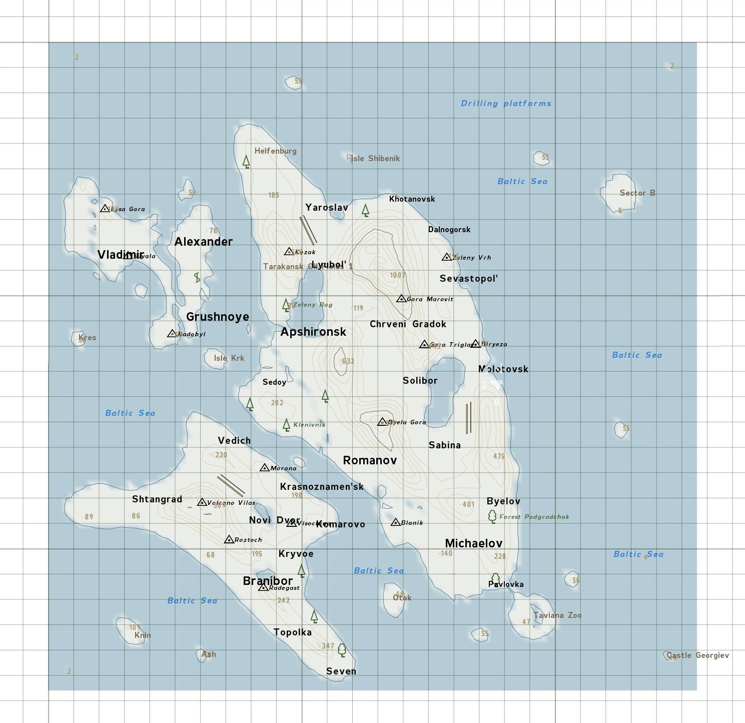
| X座標 |
Y座標 |
備考 |
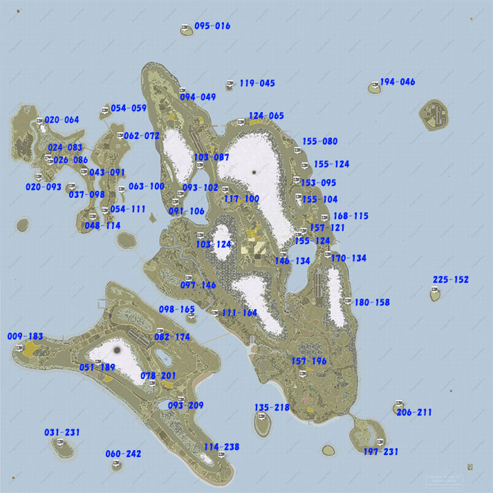
| 060 |
242 |
Island Ash. 81 meters S.W. of the light house. |
| 031 |
231 |
Island Knin. Castle Roof. |
| 037 |
098 |
S.E. of the Flying Fortress spawn point under a tree. |
| 026 |
086 |
S.E. of the alien camp in the Dead Forest on Novistrana. |
| 024 |
083 |
In the alien camp in the Dead Forest on Novistrana. |
| 024 |
084 |
In the alien camp in the Dead Forest on Novistrana. |
| 063 |
100 |
Island Izh, Novistrana. |
| 062 |
072 |
Novistrana. 15 meters S.S.W. of rocks. |
| 064 |
125 |
Isle Krk. Near the vertical grid line, N.E. corner. |
| 054 |
059 |
Bronka Castle courtyard on Novistrana. |
| 020 |
064 |
Novistrana. 57 meters N.N.W. of large rock. |
| 114 |
238 |
408 meters N.W. of Vodice water tower. |
| 078 |
201 |
121 meters N.N.W. of Castle Bled under a tree. |
| 051 |
189 |
On the map vertical grid line, S.W. corner of the map grid. |
| 098 |
165 |
Isle Myet under a tree. |
| 119 |
045 |
Isle Shibenik (prison island). |
| 095 |
016 |
Isle 55 due North of Taviana. On the map vertical grid line, N.E. corner of the map grid. |
| 194 |
046 |
Isle 55 N.W. of Sector B. Between two trees. |
| 180 |
158 |
|
| 225 |
152 |
Isle 55 due East of Taviana. Under two trees. |
| 206 |
211 |
Isle 55 N.E. of the zoo. |
| 091 |
106 |
Norilsk Military Base. On top of the southern oil silo. |
| 103 |
124 |
|
| 097 |
146 |
455 meters W.S.W. of Zhabak, next to the base of a tree. |
| 082 |
174 |
At Polinki Les, N.E. of the Krazno airfield. |
| 009 |
183 |
353 meters W.S.W. of the windmill at 013 182. |
| 135 |
218 |
Island Otok. |
| 197 |
231 |
S.E. corner of the zoo. |
| 093 |
209 |
At the Nuclear Power Plant. |
| 146 |
134 |
255 meters N.W. of Castle Nekhay at the base of a tree. |
| 111 |
164 |
At Castle Radynya |
| 155 |
104 |
158 meters South of the antenna. |
| 153 |
095 |
In a yard next to a barn. |
| 155 |
080 |
219 meters S.E. of Gora Normansk. |
| 124 |
065 |
130 meters of the grain silo in trees. |
| 048 |
114 |
113 meters N.W. of Radobyl on Novistrana. |
| 054 |
111 |
102 meters S.S.W. of Grushnoye, Novistrana. |
| 043 |
091 |
Novistrana. 361 meters west of the barn. |
| 020 |
093 |
Novistrana. 166 meters S.S.E. of Yama. |
| 157 |
196 |
Michaelov on top of a tall brown apartment on the north end of town. |
| 093 |
102 |
|
| 094 |
049 |
|
| 117 |
100 |
Lypestok on top of a tall brown apartment. |
| 103 |
087 |
Lyubob military base. |
| 155 |
124 |
Brdo Fort |
| 157 |
121 |
|
| 158 |
087 |
On the map South grid line. |